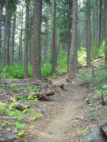
Unless you are a hardcore mountain biker, you have probably never heard of Downieville, California. In ten years of California adventuring, I had never heard of it until about a month ago! Although it is not as well known to the general public, this tiny town is a prime location for some of the best trails in the country. The famous "Downieville Classic" is actually one of the biggest downhill races in the country. There are ENDLESS opportunities for biking- from beginner trails to crazy-ass technical trails that require nerves of steel. Needless to say, if you have a mountain bike, get yourself up here!
 |
| The "Trail", don't fall off to your right! |
- The Downieville Downhill: This is the premier trail of the town, the creme de la creme, the "why-go-to-Egypt-and-not-see-the-Pyramids" type of place. It will rock you, roll you and send you happily screaming down 4,000 vertical feet of glorious single track. I did this trail as an out and back trail but there is a shuttle system that you can pay for that will cut off the huge elevation gain. This trail has jumps, technical sections, steep downhills, river crossings, and varied terrain. You definitely need a damn good mountain bike for it. What I loved most about it was that it took me about 4 hours to climb up it and about 45 minutes to descend. Wheeeee! Trail maps are available in town- if you take the shuttle, expect 29 miles of uninterrupted ascents and descents through Sierra forests and streams.
- The SBTS Mountain Epic Route: This is another route that is not too far from the town of Downieville. This is a dirtbiking trail but mountain bikers have made a claim on its route as well. This trail is also known as the "Second Divide Trail" and can be done in conjunction with the Downieville Downhill. Its much more difficult than the Downhill route- more tricky rocky sections, tighter curves, and some very "cliffy" sections. I highly recommend it though!
- Chimney Rock Trail: I haven't personally done this trail, but it was also highly recommended by local mountain bikers. This can be done through the local shuttle as well but it still involves about 5,000ft of elevation gain. It is a 28 mile trail with great views that is locally described as simply "outrageous". Let me know if you get a chance to ride this one!
 |
| Despite the well-deserved "atrociousness" of the trails, they are quite peacefull and usually empty |
That's what I said when first heard of the town. Downieville is located in the Northern Sierras, northeast of Sacramento, California. Its almost directly north of Auburn California (if you know where that is!). From anywhere in Southern California or San Francisco area, you are going to have to make it to 80- East. Auburn is 25 miles east on I-80 from Sacramento. From here, head north on Highway 49 for 70 miles to the town of Downieville. Make sure you follow the signs to stay on Highway 49- it forks off once near Grass Valley. The drive itself is beautiful and you will see some gorgeous views of the Yuba River.

This comment has been removed by the author.
ReplyDelete